Mount Sneffels (14,150 ft.) towering over its surroundings at dusk in early June. San Juan Mountains, Colorado.
Like many other landscape photographers grounded by the COVID-19 pandemic and associated travel restrictions, I have resorted to browsing through my photo archives as I dream of outdoor adventures. During one such hard drive foray I found some old unstitched panorama images and thought I’d work on putting them together finally. This photo was from a 2015 photo mission when I stayed up here well into the night to photograph the Milky Way over Mount Sneffels.
I wish you health, safety, and sanity during these uncertain times.
Clouds swirl off of Wetterhorn Peak after an intense thunderstorm.
Here are some photos from a few recent hiking and backpacking trips in the San Juan Mountains near Ridgway and Ouray. The snow is still melting up high but the lower elevations have been glorious this last month! See more recent photos here >>
A smoky sunrise as seen from the summit of Mount Wilson (14,246 ft) in the San Juan Mountains, Colorado. Wilson Peak is on the left, Gladstone Peak near the center, and the Sneffels Range barely visible through the smoke in the distance.
On Monday morning my alarm woke me at 2:00am in my tent at Navajo Lake in the San Miguel Range near Telluride, Colorado. Groggy after only four hours of sleep, I started trudging up towards Mount Wilson under the light of the waning full moon. I could smell wildfire smoke in the air, and the stars were quite dim, but I didn’t think too much of it and continued on my mission to get to the summit for sunrise. Three or so hours later, after much rock hopping and a bit of airy scrambling, I stood on the 14,246-foot summit of Mount Wilson… disappointed with the view. My hopes of a glorious clear Colorado sunrise were crushed by the sight of thick smoke filling the valleys and shrouding the mountains. As I sat on the summit waiting for morning, I knew that my sunrise photo was toast and felt like my whole endeavor was a collosal waste of effort.
But then the sun rose as a red orb filtered through the haze like a lunar eclipse, becoming oranger as it rose higher and casting a warm glow over the smoky landscape. The surreal and somewhat apocalyptic scene wasn’t what I expected but it made for a unique photo opportunity after all!
I learned later that all the smoke came from an 800-acre wildfire west of Montrose. As luck would have it, the wind was blowing due south pushing all the smoke right into the San Juans. That’s a lot of smoke for a relatively small 800-acre fire!
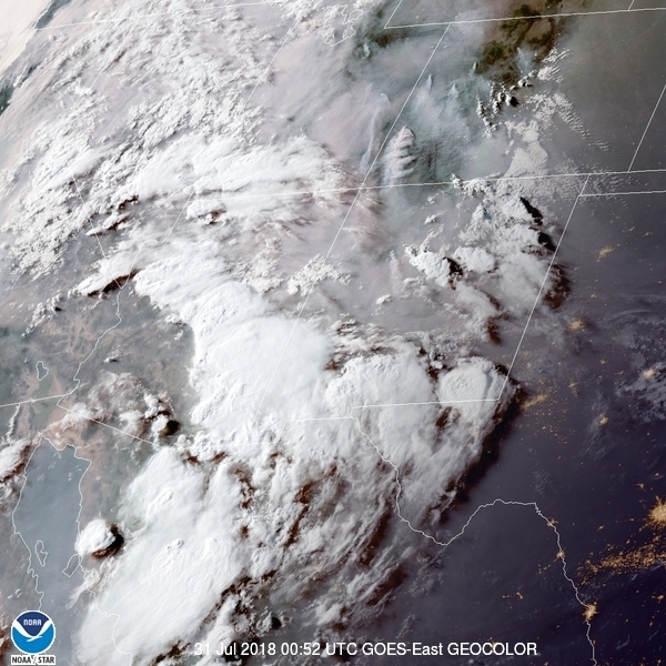
This NOAA satellite image from Monday 7/30/18 shows the Bull Draw wildfire smoke blowing south into the San Juans in southwest Colorado (just above and to the right of the Four Corners). Notice numerous other wildfires above in Colorado and Utah.
Full moon rises behind Wetterhorn Peak, a 14er in the Uncompahgre Wilderness, Colorado.
After returning home to Colorado at the end of June we did a quick one-night backpack trip in the Uncompahgre Wilderness of the San Juan Mountains in Colorado. That evening we hiked up to a high ridgeline to watch the full moon rise behind Wetterhorn Peak at sunset. It’s nice to be back in beautiful Colorado!
Looking southwest from the summit of Handies Peak (14,053 ft.) towards Sloan Lake, Jones Mountain, Niagara Peak, and La Plata Mountains in the far distance.
After a wet rainy week stuck inside the house, by Thursday I’d had enough and decided to get out and hike up Handies Peak, a fourteener here in the San Juans which I haven’t hiked before. Despite the cold wind and nasty looking clouds, I continued up the peak, encouraged by the occasional glimpse of blue sky. Sure enough, as I approached the summit the clouds started clearing off a bit, so I sat up there for a few hours bundled up in my down clothes and waited for sunset – which never really did much, but anyways it wasn’t a bad place to hang out for a while!
Fast moving clouds at dusk on the summit of Handies Peak (14,053 ft.). Redcloud and Sunshine Peaks are two more 14ers visible on the left side horizon.
On a side note, earlier this summer in July, Adam Campbell, a runner in the infamous Hardrock 100 endurance race, was nearly struck by lightning high on Handies. He and his pacer were both knocked off their feet, but otherwise uninjured, and he continued on to finish third place!
Sunset over the Crestone group, as seen from the south.
With our San Juans still covered in quite a bit of snow up high, earlier this week we drove east for 3 nights of backpacking in the Sangre de Cristo Mountains where the snow is mostly gone and summer backpacking season is well underway.
The first light of dawn illuminates Blanca Peak (14,345 ft.), the fourth highest fourteener in Colorado.
We camped the first night up near treeline below Mt. Lindsey, a fourteener I have not yet climbed. Feeling motivated, I set my alarm for 3:00am in order to hike up to the 13,400 foot summit of the “Iron Nipple” (seriously) for sunrise. This rugged peak offered a great vantage point to watch the sunrise light on Blanca Peak, the monarch of this mountain range.
Mount of the Holy Cross, 14,005 feet, as seen from Notch Mountain – Holy Cross Wilderness, October 2003.
I just dug up this photo from deep in my archives while searching for a photo request of this mountain. I took this shot way back in October 2003, just over ten years ago! Back then I was in the early stages of being serious about photography. So much has happened in my life and my photography in the decade since then… It almost seems like it should have been 20 years ago, not just ten! It’s so amazing how much life you can fit into ten years. And it makes me wonder what’s in store for the next ten years…
Anyhow, Notch Mountain, in the Sawatch Range just south of Vail, Colorado, has a perfect front-and-center view of Mount of the Holy Cross and its east facing cross couloir, made famous in 1873 by legendary wilderness photographer William H. Jackson. In the early 20th century, the mountain became a destination of Christian pilgrimages, and a rock hut was built on Notch Mountain (very close to where this photo was taken) for shelter during Sunday mass at 13,000 feet. The hut is still there, and back in October ’03 my friend Todd and I backpacked up there and used it for shelter ourselves. This was a memorable trip, so I thought I’d write up a trip report, ten years later. Continue reading “Mount of the Holy Cross”→